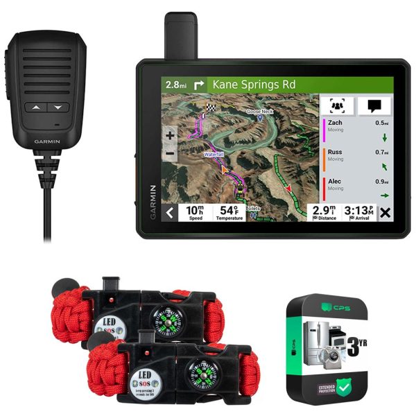


Garmin Tread SxS Edition 8 Ultrabright Powersport Navigator w Warranty Bundle Supply
Description
ROAM THE UNKNOWN
Hit the trails and have fun with your friends with this rugged powersport GPS navigator. It has all the mapping you need to stay on track and communication technology to stay in touch while you re out there.
-
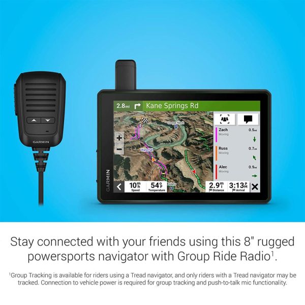
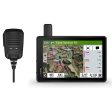
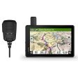
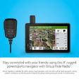
Keep your crew together with group tracking for up to 20 riders, plus push-to-talk fist mic.
-
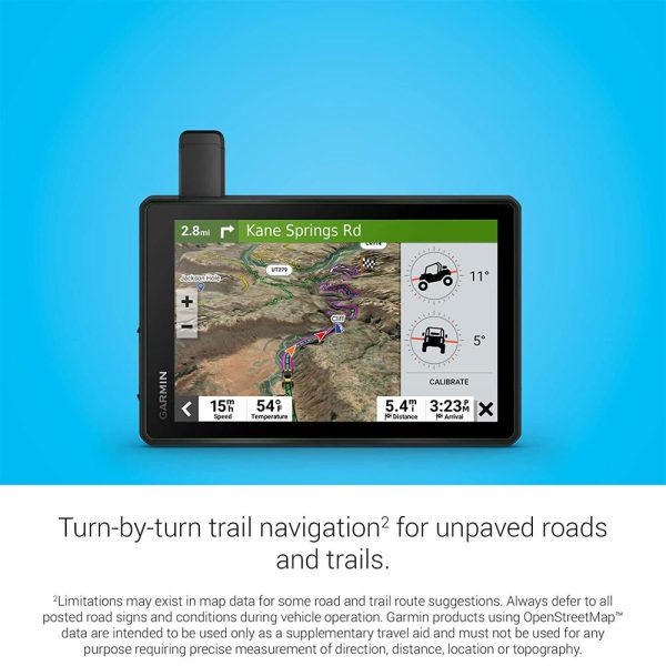
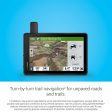
Navigate unpaved roads and trails by using turn-by-turn trail navigation1 with OpenStreetMap (OSM) and USFS Motor Vehicle Use Maps.
-
This rugged navigator is IP67 weather-resistant and has a glove-friendly 8 touchscreen display.
-
See vivid aerial views of terrain with downloadable, subscription-free BirdsEye Satellite Imagery.
-
Use the Tread app on your compatible smartphone for the Group Ride Mobile feature, easy route planning and more.
-
Peace of mind comes built-in. With an active subscription, you can use inReach technology for global satellite communication.
-
RIDING RADIO FOR GROUP GETAWAYS
The included Group Ride Radio allows tracking for up to 20 Tread-equipped riders with no cellular coverage needed. Plus, the push-to-talk fist mic lets you easily stay in communication with your Group Ride friends. Pair Tread with your helmet or headset (not included) enabled with BLUETOOTH technology for hands-free communication.OFF-ROAD RUGGEDNESS
Purpose-built for all-terrain use, this Tread device stands up to anything the elements can throw at it. It s IP67-rated for water-resistance and built to U.S. military standard 810G for thermal and shock resistance.HIGH-VISIBILITY DISPLAY
With its ultrabright 8 glove-friendly touchscreen, the navigator is designed for easy viewing in bright sunlight or pitch dark. It can be mounted in portrait or landscape mode.TRAIL NAVIGATION
Enjoy turn-by-turn trail navigation1 for traversing unpaved roads and trails using adventure roads and trails map content comprised of OSM and USFS Motor Vehicle Use Maps.BUILT-IN INREACH TECHNOLOGY
Built-in inReach technology offers global satellite communication2, two-way text messaging, location sharing and interactive SOS.MAPS ON AND OFF-ROAD
Tread features preloaded topographic maps with 3D terrain for North and Central America. It also includes detailed street maps of North America with Garmin Adventurous Routing options to take scenic and curvy routes.KNOW YOUR BOUNDARIES
Access U.S. public land boundaries for national forests, Bureau of Land Management (BLM), wilderness areas and more. Also, see U.S. private land boundaries and landowner information for parcels greater than 4 acres.SATELLITE IMAGERY
Enjoy vivid aerial views when you download high-resolution BirdsEye Satellite Imagery directly to your device via Wi-Fi connectivity, with no annual subscription required.ABC SENSORS
When you re headed to tough-terrain, the built-in sensors will come in handy – including an altimeter, barometer, compass and pitch roll gauges.SECURE MOUNT
The included locking magnet-assisted mount and tube mount secure your Tread navigator to your powersport vehicle for riding over rough terrain.GROUP RIDE MOBILE
Track friends from your compatible smartphone or Tread device when you and your friends use the Tread app s Group Ride Mobile feature.EASY ROUTE PLANNER
Use the Tread app to easily plan routes with the same maps, vehicle profiles and route preferences that you have on the Tread device.EASILY SYNC YOUR DEVICES
Use the Tread app to sync waypoints, tracks, routes and collections across all your devices. Easily import and share GPX files, too.LIVE WEATHER
Weather ahead? Pair your Tread device with your compatible smartphone, and download the Tread app to access live weather, storm alerts, animated radar and more.CONTROL YOUR ACCESSORIES
Pair Tread with the compatible Garmin PowerSwitch digital switch box (sold separately) to enable on-screen control for your vehicle s 12-volt electronics – light bars, differential locks and more.TRACK YOUR DOG PACK
Wirelessly pair Tread with select Garmin GPS dog trackers (sold separately) to help track and retrieve your sporting dogs in the field. You ll see markers for each dog within tracking range, overlaid right on the navigator s map screen.EXPAND YOUR RANGE
Get enhanced performance with the robust external GPS antenna and external inReach antenna. Both are in a low-profile, water-resistant housing and have many installation options. Each sold separately.TRAVELING MUSIC
A built-in media player lets you easily control music loaded on your compatible smartphone on the navigator s display – and hear your tunes through your helmet or headset (not included) enabled with BLUETOOTH technology.POINTS OF INTEREST
Tread comes preloaded with iOverlander points of interest and Ultimate Public Campgrounds, so you don t need a cell signal to route to the best-established, wild and dispersed campsites.Product Specifications:
General
PHYSICAL DIMENSIONS
8.1 W x 6.7 H x 1.2 D (20.7 x 16.9 x 3.1 cm)DISPLAY SIZE
6.8 W x 4.2 H (10.8 cm x 17.2 mm); 8 diagonal (20.3 cm)DISPLAY RESOLUTION
1280 x 800 pixelsDISPLAY TYPE
multi-touch, glass, high brightness HD color TFT with white backlightDUAL-ORIENTATION DISPLAY
YesWEIGHT
22.8 oz (646 g)BATTERY TYPE
rechargeable lithium-ionBATTERY LIFE
Up to 6 hours at 50% backlight
Up to 1 hour at 100% backlightWATER RATING IPX7
YesDROP RATING MIL-STD-810
YesDUST RATING IP6X
YesMAGNETIC MOUNT
locking magnet-assisted mountTUBE MOUNT (1.5 – 2.375 )
Yes1.5 BALL ADAPTER WITH AMPS PLATE
YesMaps & Memory
PRELOADED STREET MAPS
YesHIGH DEFINITION 3D TERRAIN
YesDATA CARDS
microSD card (not included)3D TERRAIN
YesINTERNAL STORAGE
Yes 64 GBABILITY TO ADD MAPS
YesEXTERNAL MEMORY STORAGE
yes (256 GB max microSD card)INCLUDES MAP UPDATES
YesDOWNLOADABLE SATELLITE IMAGERY yes (BirdsEye)
Sensors
GPS
YesGALILEO
Yes10 HZ MULTI-GNSS POSITIONING
YesBAROMETRIC ALTIMETER
YesCOMPASS
YesOutdoor Recreation
POINT-TO-POINT NAVIGATION
YesPRELOADED TOPOGRAPHICAL MAPS
YesPRELOADED US PUBLIC LAND BOUNDARIES
YesPRELOADED PRIVATE LAND PARCEL MAPS
yes (parcels greater than 4 acres)PRELOADED USFS ROADS AND TRAILS, INCLUDING MOTOR-VEHICLE-USE-MAPS FOR MOTORCYCLE, ATV, SXS AND FULL-SIZE 4X4
YesNAVIGATE-A-TRACK NAVIGATION
YesTURN-BY-TURN TRAIL NAVIGATION
YesNavigation Features
GARMIN REAL DIRECTIONS LANDMARK GUIDANCE
YesTRIPADVISOR TRAVELER RATINGS
YesROUTE SHAPING THROUGH PREFERRED CITIES STREETS
YesINCLUDES TRAFFIC
yes (with Garmin Tread app)LANE ASSIST WITH JUNCTION VIEW (DISPLAYS JUNCTION SIGNS)
YesSPEED LIMIT INDICATOR (DISPLAYS SPEED LIMIT FOR MOST MAJOR ROADS IN THE U.S. AND EUROPE)
YesDRIVER ALERTS FOR SHARP CURVES, SCHOOL ZONES, RED LIGHT AND SPEED CAMERA WARNINGS AND MORE
YesAdvanced Features
SMART NOTIFICATIONS VIA APP
YesWI-FI MAP AND SOFTWARE UPDATES
YesACCESS TO LIVE SERVICES VIA APP (TRAFFIC, WEATHER, ETC.)
YesMotorcycle Features
GLOVE-FRIENDLY TOUCHSCREEN
YesCONTROL MUSIC AND MEDIA FROM SMARTPHONE OR MP3 PLAYER
YesSUNLIGHT READABLE AND WEATHER RESISTANT
YesGARMIN ADVENTUROUS ROUTING
YesMOTORCYCLE OR POWERSPORTS SPECIFIC POINTS OF INTEREST FOR CYCLE REPAIR SERVICES, DEALERS AND MORE
YesELEVATION PROFILE
YesROUND TRIP ROUTING
YesSERVICE HISTORY LOG
YesCUSTOM MAP SUPPORT
YesTOPO MAP SUPPORT
YesRV Features
SPECIALIZED ROUTING FOR THE SIZE AND WEIGHT OF YOUR VEHICLE
YesRV PARKS & SERVICES DIRECTORY
YesROAD ELEVATIONS
YesSPEED LIMIT CHANGES
YesEASY ROUTE PLANNER WITH GPX FILE SHARING
YesAdventure Features
BUILT-IN INREACH TECHNOLOGY (REQUIRES ACTIVE SUBSCRIPTION; SUBJECT TO REGULATIONS OR PROHIBITIONS IN SOME JURISDICTIONS)
YesPAIR WITH GARMIN POWERSWITCH DIGITAL SWITCH BOX
YesCOMPATIBLE WITH GROUP RIDE RADIO Yes (included)
YesCOMPATIBLE WITH EXTERNAL GPS ANTENNA WITH MOUNT
YesCOMPATIBLE WITH EXTERNAL INREACH SATELLITE ANTENNA
YesGROUP RIDE MOBILE
yes (with Garmin Tread app)TRACK RECORDER (BREADCRUMBS)
YesIOVERLANDER POINTS OF INTEREST
YesULTIMATE PUBLIC CAMPGROUNDS
YesPITCH AND ROLL GAUGES
YesBIRDSEYE SATELLITE IMAGERY (DOWNLOAD VIA WI-FI)
YesGroup Ride Radio
RADIO FREQUENCY BAND MURS (151-154 MHz)
YesGROUP RIDE RANGE
typically 1 mileGROUP RIDE TRACKING
up to 20 riders simultaneouslyGROUP RIDE UPDATE RATE
2.5 secGROUP RIDE VOICE COMMUNICATIONS
yes (with included fist mic or paired BLUETOOTH headset)FIST MIC COMPATIBILITY
Also works with other MURS VHF radios (151 MHz – 154 MHz)RADIO TRANSMITTED CANNED MESSAGES
YesOutdoor Applications
DOG TRACKING
yes (when paired to compatible dog track system)Footnotes:
1 Limitations may exist in map data for some road and trail route suggestions. Always defer to all posted road signs and conditions during vehicle operation. The Garmin OpenStreetMap products are intended to be used only as a supplementary travel aid.
2 Active satellite subscription required for the inReach features. Some jurisdictions regulate or prohibit the use of satellite communications devices. It is your responsibility to know and follow all applicable laws in the jurisdictions where the device is intended to be used.
The Bluetooth word mark and logos are registered trademarks owned by Bluetooth SIG, Inc. and any use of such marks by Garmin is under license. Satellite Imagery © 2021 Maxar Technologies (date of satellite imagery may vary). Wi-Fi is a registered trademark of the Wi-Fi Alliance. Copyright 2022 by iOverlander, LLC. Copyright © 2022 Ultimate Campgrounds – All rights reserved.
Additional Information
| Title | Default Title |
|---|